

ClimbZA - Strubens Route Guide

ClimbZA - Strubens Route Guide का विवरण
A route guide for the rock-climbing routes at Struben's Valley in Johannesburg (South Africa), allowing you to leave that dirty, dog-eared, and now barely legible set of printed wiki pages (half of which are missing anyway) at home.
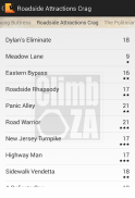
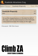
This initial release includes just the basic functionality - a list of the routes, their grades and protection, as well as the detailed route descriptions.
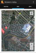
Also included is a Google map of the area and a some general information that may be useful to anyone new to the area.
Although the guide is useable on a tablet, it really is primarily designed for use on a phone at the crag.
</div> <div jsname="WJz9Hc" style="display:none">यदि आप घर पर (वैसे भी याद कर रहे हैं जिनमें से आधे) मुद्रित विकी पृष्ठों की है कि गंदे, कुत्ते के कान, और अब मुश्किल से सुपाठ्य सेट छोड़ने के लिए अनुमति देने के जोहानसबर्ग में Struben की घाटी (दक्षिण अफ्रीका) में रॉक क्लाइंबिंग मार्गों के लिए एक मार्ग गाइड.
मार्गों, उनके ग्रेड और सुरक्षा, साथ ही विस्तृत मार्ग विवरण की एक सूची - यह आरंभिक रिलीज सिर्फ बुनियादी सुविधा भी शामिल है.
इसके अलावा क्षेत्र के एक गूगल मानचित्र और क्षेत्र के लिए नए किसी के लिए उपयोगी हो सकता है कि एक कुछ सामान्य जानकारी शामिल है.
गाइड एक गोली पर useable है, यह वास्तव में मुख्य रूप से ग्रीवा पर एक फोन पर इस्तेमाल के लिए बनाया गया है.</div> <div class="show-more-end">


